
Data with benefits: Optimise your emergency management CAD system
There's no denying that every second counts when it comes to saving a life. Emergency services dispatchers rely on highly accurate location data to know exactly where to direct response units.
And now with the compounding impact of city growth in both population and infrastructure, it is possible for location data to become obsolete or inaccurate at a rapid rate. Even temporary changes can hinder a dispatcher in their response.
When we consider how most computer aided dispatch (CAD) systems ingest data from providers on a three-month schedule; it is easy to understand discrepancies can occur. So how can you ensure your CAD system is the most updated and efficient it can be? HERE Map Data may just be the data solution for your emergency services needs.
What makes HERE Map Data the best choice?
HERE Map Data is a complete data solution for emergency services. It integrates three key components that make it a standout choice - these include the most accurate points of interest data available, a routable network layer and road centreline geometry.
In addition to these features, HERE Map Data can improve your data latency. The most updated data is ingested to ensure crucial information for response efforts is available to your organisation—consisting of unique traffic incident sources, vehicle and smartphone sensor data, national and regional traffic information and roadworks data providers.
Points of Interest
Your communications centre will likely receive calls from businesses or other establishments that are in a crisis situation. Let’s imagine for a moment that the store manager of a supermarket chain calls to report a fire in their warehouse. They explain to the dispatcher where the shopping centre complex is, but both parties know that this does not narrow down the location enough. The caller can explain that the warehouse is opposite a service station on the road outside, and this will direct the fire response team to the exact location. In order for this to work, first responders need business and Points of Interest (POI) data that is constantly accurate.
HERE Map Data helps refer to the location of an emergency in relation to landmarks or POI—and it’s the most sophisticated data offering of its kind in the market. This allows users to have the flexibility to input POI on a map to cover off places around a city or town that people could refer to as their location, that may not have an actual street address. Another example of this might be a beach name, boat ramp or bridge. Therefore, the dispatcher and the response team are both empowered to attend the incident as efficiently as possible.
Whatsmore, HERE Map Creator allows the user to input road, address, business and POI information into a HERE Map. The result? A localised, highly accurate map which will inform emergency responders in critical moments when they need clear directions. This unique aspect of HERE Map Creator means that the public can influence the HERE Mapping database, localising the data and ultimately enriching the map with a true reflection of the surrounding built environment.
Routable network analyst layer
This component of the HERE Map Data offering displays what assets can be allocated and what the response time would be for any given response team. Furthermore, the routable network layer can recommend crew turnouts to the dispatcher, based upon the GPS in the truck, giving the most accurate and to-the-minute information available. Once a unit is allocated to respond to an incident, the routable network analyst layer offers the fastest route to the incident and includes turn-by-turn navigation read aloud to the driver.
Whatsmore, the full extent of the routable analyst layer can help with infrastructure planning and assessment. This can be achieved by creating an isochrone map that displays the maximum response time emergency response teams have in areas of a city. The resultant information can empower emergency services to understand where response times are lacking and identify where more assets should be allocated to increase the coverage.
This feature allows for the option to overlay live traffic data too. For instance, you could observe how peak traffic periods modify the response times in different areas of the city and plan for any under-resourced areas.
Road centreline geometry
In an emergency situation, people that are panicked can refer to addresses that are ungazetted (unrecognised by the shire). A simple mistake can have serious implications on response times, particularly the first responders to a scene. With the HERE Technologies roadline centre geometry feature, addressing information is attributed according to left and right sides of this street, enabling for double redundancy with addressing.
Take this example, as pictured in Figure 1; a fire occurs at 110 Main Avenue. Someone calls to report a fire and references the address as 110 Main Avenue. But, because the block has been subdivided to accommodate more homes than was originally planned, that address isn't actually gazetted.
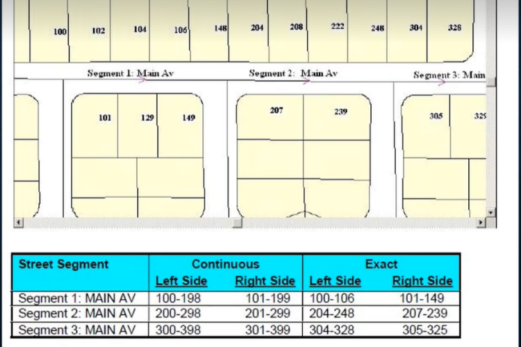
Figure 1 - Road centreline example.
Source - Motrola Premier One CAD GIS User Guide Version 4.5
What then happens is the dispatching/routing system would interpolate where on that section of road that 110 would be. To achieve this, the system would figuratively break up the entire road segment into individual pieces based on the count of the number range. Where the individual road segment section hit 110, the address is interpolated at that point and thus would route to that location based upon where the system has interpolated 110 to be. Without the assistance of the road centreline geometry, the CAD system and dispatcher would struggle to find the address given. However, with HERE Map Data, the location of the incident will be found and attended.
Where to next?
Extensive data gathering efforts are made simple with HERE. Emergency management agencies that once would have relied upon drawing upon multiple data providers, can rely on the HERE data set to source and collate all the necessary data points. In turn, this streamlined data access reduces costs and time associated with managing multiple suppliers and data pipeline processes.
The range of data available with HERE Map Data is second to none. In instances where there is no time to waste, you want the best tools to hand and that is exactly what HERE can offer. To get in touch with our experienced team of experts at Next Mile Location Technology, reach out to us via our contact form.